FOR-69: Field Guide to Best Management Practices for Timber Harvesting in Kentucky
Stream beds should not be used as roads or for the skidding of logs except where site conditions (rock walls, notches, or other limiting factors) leave no other alternatives for access or where road or skid trail placement in normally recommended locations is either impossible or will cause a higher degree of water quality degradation.
Perennial waters contain water throughout the year. Recommendations are given for four types of perennial waters including:
| Table 3-1--Specifications for Regular Streams and Other Waters | ||||
| Slope of Ground Next to Bank | Width of Trees (Surface Distance) | Overstory Trees Retained | Understory Trees and Shrubs | Distance of Disturbed Ground to Bank |
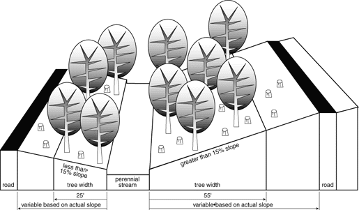
| less than 15 percent | 25 feet | 50 percent | minimal disturbance | see Table 3-1 |
| greater than 15 percent | 55 feet | |||
| Table 3-2--Minimum Distances from Perennial Water Bodies to Roads, Trails, or Landings1 | ||
| Slope of Land (%) Away from Stream Bank | Width of Zone (feet) Away from Stream Bank | |
| 0 | 25 | |
| 5 | 35 | |
| 10 | 45 | |
| 15 | 55 | |
| 20 | 65 | |
| 25 | 75 | |
| 30 | 85 | |
| 35 | 95 | |
| 40 | 105 | |
| 50 | 125 | |
| 60 | 145 | |
| 70 | 165 | |
Figure 3-1—Streamside Management Zone Specifications for Perennial Warm Water Aquatic Habitats
2. Coldwater Aquatic Habitats (CAHs) See Appendix B for locations of Coldwater Aquatic Habitats.
| Table 3-3--Specifications for Coldwater Aquatic Habitats | |||
| Width of Trees (Surface Distance) | Overstory Trees Retained | Understory Trees and Shrubs | Distance of Disturbed Ground to Bank |
| 60 feet regardless of slope | 75 percent | no disturbance | see Table 3-1 |
3. Perennial Streams, Ponds, and Sloughs in Wetlands. Also see BMP No. 10 for further information on wetlands.
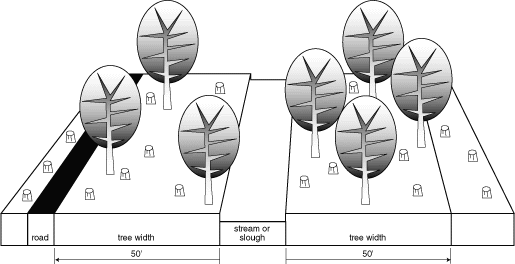
Leave a minimum of 50 percent of the overstory trees to shade perennial streams, ponds, and sloughs.
| Table 3-4--Specifications for Perennial Streams, Ponds, and Sloughs in Wetlands | |||
| Width of Trees (Surface Distance) | Overstory Trees Retained | Understory Trees and Shrubs | Distance of Disturbed Ground to Bank |
| 50 feet regardless of slope | 50 percent | minimal disturbance | 50 feet (unless crossing) |
Figure 3-2. Streamside Management Zone Criteria for Streams and Sloughs in Wetlands
4. Specially Designated Perennial Waters. Certain streams and rivers are designated for special protection, including:
Intermittent streams flow only during the wet portions of the year and in response to rain events.
In areas adjacent to intermittent streams, avoid equipment operation in a zone of at least 25 feet on each side of an intermittent stream except for designated crossings, where possible. Tops or other logging debris that may block the intermittent stream channel should be removed or placed in such a way that they will not cause a blockage.
| Table 3-5--Specifications for Intermittent Streams | |||
| Width of Trees | Overstory Trees Retained | Understory Trees and Shrubs | Distance of Disturbed Ground to Bank |
| 0 feet | 0 percent | minimal disturbance | see Table 3-6 (unless crossing) |
| Table 3-6--Minimum Distances from Intermittent Streams to Roads, Trails, or Landings1 | ||
| Slope of Land (%) Away from Stream Bank | Width of Zone (feet) Away from Stream Bank | |
| 0 | 25 | |
| 5 | 30 | |
| 10 | 35 | |
| 15 | 40 | |
| 20 | 45 | |
| 25 | 50 | |
| 30 | 55 | |
| 40 or higher | 65 | |
Figure 3-3—Streamside Management Zone Specifications for Intermittent Streams
Important: While no standing tree width is required, tree tops cannot be left in intermittent streams and should not be placed so as to wash into a stream. Use a standing tree zone to lodge tops, if necessary. Floodplain Regulations may apply (See Appendix A).
See floodplain regulations in Appendix A for requirements necessary for building crossings. Tree tops and debris should not be left so they could obstruct water flow in perennial or intermittent streams.